 Search Articles

BATON ROUGE, La. (CN) — Louisiana loses roughly a basketball court sized portion of land every five minutes — one of the largest rates of land loss on Earth.
The chunks of land, mostly wetlands, are disappearing primarily because of human activity, including from a stringent levee system along the Mississippi River that has separated the river from nutrients and sediment in some portions for three centuries. Still, a staggering bulk of the loss has been over the past 100 years, with nearly 1,900 square feet lost since 1930. Saltwater seeps into wetlands from manmade canals, used for shipping purposes and by the oil and gas industry. At the same time, the land is sinking, and the sea level is rising.
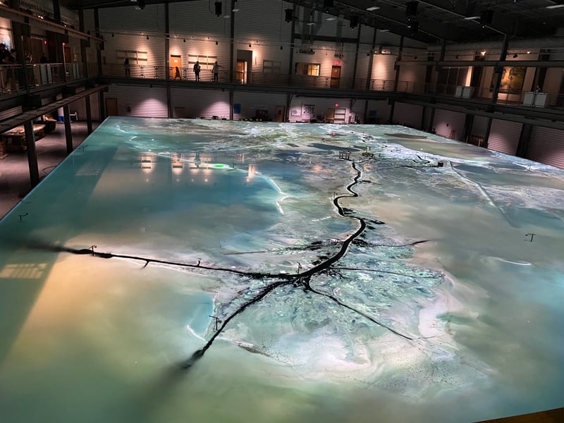
To study changes in the waterway, researchers at Louisiana State University’s Center for River Studies look to a giant replica of the lower Mississippi River. Measuring 90 by 120 feet long, it is designed to simulate flows, depth and sediment transport, and helps scientists better understand how the river responds to modifications.
The university operates the $18 million model, unveiled in 2017 and built with funding from the Louisiana Coastal Protection and Restoration Authority. Its movable bed produces semi-quantitative results describing sediment flow and distribution in the lower Mississippi River, from where the model sits inside a 45,500-square-foot facility.
Project manager Rudy Simoneaux described the model as a “combination of science and a working laboratory as well as public outreach,” in an interview with Baton Rouge’s 225 Magazine the year it was installed.
“We’re in the midst of a coastal crisis, and there are some people who don’t think there’s anything being done about it. So we can use this to show people we’ve been busy, we plan to get busier, and here’s why.”
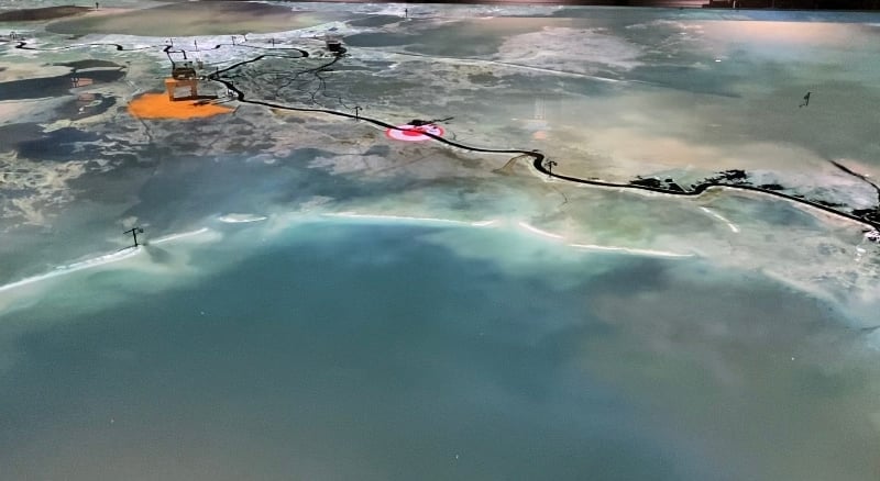
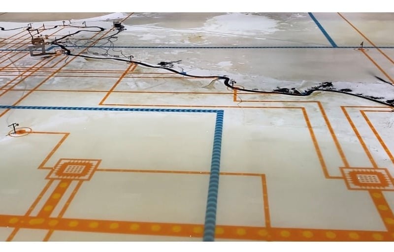
The river model represents 179 miles of lower Mississippi River, from Donaldsonville outside Baton Rouge to its final plunge into the Gulf of Mexico. It is one of the largest of its kind in the world, using billions of data points to represent sediment movement in the lower Mississippi River. Twenty high-resolution projectors mounted above the model bed project aerial photographs, project features, diversion outputs and other simulations.
Louisiana Coastal Protection and Restoration Authority is in the midst of developing simultaneous sediment diversion and marsh rebuilding projects, in a push to protect the state’s fragile coastline.
Through the river model, the state authority can create and observe multiple scenarios to see how particular events might impact those projects — for example, what happens when a section of the river is high, and diversion canals must be opened. Or, most recently, what happens when the river is too low and a saltwater crest travels upriver, a rare situation verging on unprecedented.
“We try to think of it as three tools: the people out in the field – out collecting data and studying what’s happening to the river — then numerical modeling with computers, and then this physical model,” Simoneaux said of the model. “So all three can provide even stronger evidence.”
Before the first sediment diversion project planned through the coastal authority, the Mid-Barataria Sediment Diversion Project, broke ground in August, the river model was instrumental in charting the potential impacts of the project.
That project is aimed at restoring and sustaining freshwater marshes in the Barataria Basin, which spans 600,000 acres of swampland of varying salinity levels, from freshwater to saltwater. It lies to the immediate south and west of New Orleans, and is protected from the Gulf of Mexico by a chain of barrier islands that are shrinking rapidly, due to a variety of factors including the water surrounding the basin growing saltier, wave activity increasing and the sea level rising.
Coastal restoration authorities aim to use a series of basins and gates to bring the Mississippi River back into the Barataria Basin, and to use river sediment to rebuild the wetlands there. The goal is the creation of 26,000 new acres of wetlands over the next 50 years.
“We’re protecting the livelihood of everyone who lives in this part of Louisiana by restoring the marsh and creating this buffer between our people and the Gulf of Mexico,” Governor John Bel Edwards said in a press release. “We’ve lost two thousand square miles. We have a real sense of urgency.”
On Sunday, the LSU Center for River Studies hosted a Community Coastal Day at its Water Campus, hosting a slate of organizations working to keep the coast from disappearing.
Groups including Vanishing Paradise, a division of the National Wildlife Federation, Center for Planning Excellence, and Audubon Society briefed the public on challenges facing the Gulf region.
Marina Gelpi Clay, director of communications and engagement for the Coastal Protection and Restoration Authority, declined to comment Monday on the impact of the saltwater wedge traveling upriver from the Gulf of Mexico due to extremely low water levels in the river — including what impact the saltwater might have on the Mid-Barataria protect.
Gelpi Clay said in her email that the U.S. Army Corps of Engineers is managing the river and would have to speak on the impacts of the saltwater.
Representatives from the Army Corps of Engineers did not immediately reply to emailed requests for comment.
 Follow @SabrinaCanfiel2
Subscribe to our free newsletters
Our weekly newsletter Closing Arguments offers the latest about ongoing trials, major litigation and rulings in courthouses around the U.S. and the world, while the monthly Under the Lights dishes the legal dirt from Hollywood, sports, Big Tech and the arts.