 Search Articles

(CN) — Broiling under another day of record-breaking heat, Northern California is now bracing for more wildfires and the likelihood of rolling blackouts as demand for electricity will likely outstrip supply Tuesday afternoon.
Most counties will see temperatures in the triple digits until the weekend, fueling concerns about strain on the state’s already challenged power grid and extreme fire danger. California Independent System Operator issued a Flex Alert for the seventh consecutive day Tuesday, calling for customers to reduce energy usage during afternoons and evenings when demand skyrockets and solar energy drops.
Several wildfires rage in areas with difficult terrain under extremely dangerous hot, dry and windy conditions.
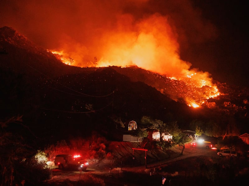
The Mill Fire broke out near the town of Weed on Friday, claiming two lives and leaving about 100 structures damaged or destroyed. It has blackened more than 4,000 acres and is 55% contained as of Tuesday morning according to Cal Fire.
While the cause of the fire remains under investigation, Weed Mayor Kim Greene told ABC News the Mill Fire ignited in an old warehouse at Roseburg Forest Products, located near a park and a number of homes which are nearly all destroyed. The blaze has forced more than 300 people to flee and is threatening about 690 structures, officials say. Governor Gavin Newsom has declared a state of emergency in Siskiyou County to support the response to the fires, which are difficult to fight due to hot and dry conditions with poor relative humidity recovery overnight, amid steep terrain and critically dry vegetation.
Nearby, the Mountain Fire has raged across 11,500 acres and is just 20% contained.
Another fire in Placer County, dubbed the Hill Fire, has charred at least 20 acres and is threatening areas around the American River Canyon. Firefighters are on the ground placing lines in steep vegetation despite surging high temperatures which hit 106 degrees Fahrenheit before noon, according to Cal Fire.
The late-season heat wave comes as California withers in the third year of another drought — with parts of the Sacramento and Central Valley in extreme or exceptional drought — and many vegetation zones are considered “critical” and highly flammable. Sustained periods of extreme heat combined with excessive drought have officials fearing new blazes as meteorologists warn there will be little relief until the weekend.
Dalton Behringer, a meteorologist for National Weather Service San Francisco, said temperatures were expected to be highest Tuesday, likely three to five degrees higher in most cities than they were Monday.
The San Francisco Bay Area saw 11 all-time-high records for September shattered on Sept. 5, including San Francisco International Airport, Oakland Museum and downtown San José. Livermore took the prize for the region’s hottest day at 116 degrees, followed by Gilroy and Santa Rosa at 112 degrees — although the coolest city in the region was Half Moon Bay at 63 degrees.
“Tomorrow we will expect a little bit of a drop, not much,” Behringer said. Coastal areas will cool more quickly, but most counties will suffer through high overnight temperatures until Saturday.
The National Weather Service’s Sacramento office also reports that on top of extended high temperatures, monsoon moisture will bring a slight chance of thunderstorms to the northern Sierra Nevada and possibly more over the weekend. An incoming trough moving into the Pacific Northwest on Wednesday could help reduce heat, although most of the Central Valley will continue seeing highs around 110.
“We may also see another batch of mid-levelmoisture move up from the southeast leading to a better chance of late-day thunderstorms over the northern Sierra. A few storms may also develop over northwest California,” according to the service’s discussion released Tuesday.
Temperatures are expected to jump again and possibly set new widespread daily records Thursday and Friday, with possible late-day thunderstorms in the Sierra south of Lake Tahoe.
PG&E advised customers to reduce power usage between 4 p.m. to 9 p.m. to help reduce stress on the statewide power grid. While the company does not expect a public safety power shutoff during the heat wave, the California ISO — which oversees the power grid — is forecasting Tuesday’s peak statewide electricity demand to be 50,087 megawatts, just below the 2006 record of 50,270 megawatts.
 Follow @nhanson_reports
Subscribe to our free newsletters
Our weekly newsletter Closing Arguments offers the latest about ongoing trials, major litigation and rulings in courthouses around the U.S. and the world, while the monthly Under the Lights dishes the legal dirt from Hollywood, sports, Big Tech and the arts.