 Search Articles

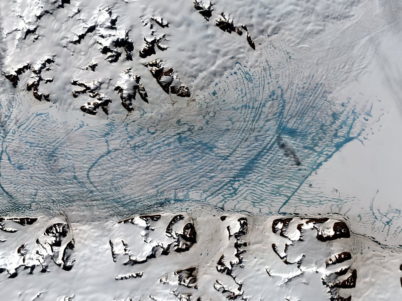
(CN) — Thanks to satellite imaging technology, scientists can track seasonal changes in Antarctica for the first time. In a study published Thursday in The Cryosphere, researchers at the University of Cambridge and Austrian engineering company ENEVO detailed their findings that can lead to more accurate sea-rise calculations.
In contrast to its northern counterparts, such as the Greenland Ice Sheet, historically, there has not been data on the Antarctic ice flow. However, there was a general assumption by scientists that it was not subject to the same seasonal movements, especially in areas with large ice shelves and consistent below-freezing temperatures.
Using data from the Sentinel-1 radar satellite through the European Space Agency and NASA’s optical Landsat 8, the researchers found recognizable seasonal movements flowing from glaciers into the George VI Ice Shelf, which is larger than the state of New Jersey. Specifically, there is a 15% increase in the glaciers feeding the ice shelf during the summer.
“Seasonality is important because, at the moment, all the estimations of how much mass is being lost from Antarctica don’t account for the fact that there’s any kind of seasonality or change in how fast the ice is flowing each season. It means that our current estimates are either over or underestimating how much mass is lost from Antarctica,” said Karla Boxall from Cambridge’s Scott Polar Research Institute in an interview. “Our projections of sea level rise are also going to be off.”
The satellite advancements allowed scientists to get images every six days of the glacier. Then, using offset tracking, they could compare the images and measure the speed of change. The use of both satellites that both found the same data allowed photos — rain or shine.
“Optical measurements can only observe the Earth’s surface on cloud-free days during summer months,” said co-author Dr. Thomas Nagler, ENVEO’s CEO, in a press release. “But by using Sentinel-1 radar imagery, we were able to discover seasonal ice-flow change thanks to the ability of these satellites to monitor year-round and in all-weather conditions.”
The cause of the seasonal changes is to be determined. There are two primary schools of thought- that the ocean current is warmer and melting the glaciers from below or that the surface meltwater is acting as a lubricant.
“These seasonal cycles could be due to either mechanism or a mixture of the two. Detailed ocean and surface measurements will be required to understand fully why this seasonal change is occurring,” said study co-author Dr. Frazer Christie in a press release.
This study serves as a significant building block in the continued science of Antarctic seasons, sea-level rise, and ice-mass loss.
 Follow @smolestwriter
Subscribe to our free newsletters
Our weekly newsletter Closing Arguments offers the latest about ongoing trials, major litigation and rulings in courthouses around the U.S. and the world, while the monthly Under the Lights dishes the legal dirt from Hollywood, sports, Big Tech and the arts.