SAN FRANCISCO (CN) — A 2,000-mile-long atmospheric river has set its sights on California, which has already seen near-record snow and rainfall this winter. But this one is different than the series of storms that pummeled the state in January.
It's warm.
San Francisco Bay Area meteorologist Daniel Swain on Tuesday described the coming storm as “a moderate to strong atmospheric river, with origins in the subtropics near Hawaii.” Forecasters say the opening wave will hit late Thursday along the Northern California coast and spread across the state Friday.
“This event will most likely be a ‘strong’ (but not ‘extreme’ or ‘exceptional’) event — comparable in magnitude (from an integrated water vapor transport perspective) with multiple events that occurred back in December and January in California,” Swain said.
“The Pacific weather setup causing all this chaos is a pretty classic one from a Pineapple Express perspective: a strong ridge of high pressure in the Gulf of Alaska is being ‘undercut’ by a strengthening subtropical jet stream — allowing subtropical moisture from near Hawaii to ‘phase’ with moderately strong but colder low pressure systems diving southward on the east side of the GOA ridge. This puts California squarely in the path of warm atmospheric rivers that form over the Northeastern Pacific.”
Meanwhile, a persistent low that's been spinning off the coast of California since this past weekend will continue to send waves of fairly low snow — 1,500 to 2,000 feet — through the rest of Wednesday. But starting Thursday, snow levels will rapidly rise to 6,500-8,000 feet or higher by early Friday before colder air mixes in. Lower elevations could see thunderstorms through Saturday.
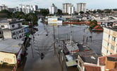
The warm and wet storm means that a lot of snow that fell at lower elevations could melt, and with widespread moderate to heavy rain across most of Northern California and parts of the Central Valley hydrologists expect to see "moderate rises on larger rivers and perhaps sharper rises on smaller rivers and streams,” Swain said. That could drive minor flooding in central state rivers, particularly smaller tributaries of the San Joaquin draining the central and southern Sierra western slope watersheds.
However, maximum rainfall rates and wind gusts “will likely be lower during this event than previous events this season,” Swain noted.
Swain said that what makes this storm stand out will be what it does to an already impressive snowpack. Thanks to an extraordinary February for snowfall, the snowpack is already at 190% of average statewide, according to the Department of Water Resources’ snow survey March 3 — just behind the record in 1982-1983.
“But the benefits vary by region, and the Northern Sierra, home to the state’s largest reservoir Lake Shasta, is lagging behind the rest of the Sierra,” Department of Water Resources director Karla Nemeth said. “It will also take more than one good year to begin recovery of the state’s groundwater basins.”

UC Berkeley’s Snow Lab reported on Twitter Monday: “The #snow over the weekend brought our total to 48.33 feet for the year, which is 0.56 feet above the 2016/2017 total of 47.77 feet. But, 2017 still has an advantage compared to this season: snow water equivalent (water that comes from melting snow).”
The greatest risk of flooding from the coming storm could be in the coastal ranges and Sierra foothills, Swain said, because adding liquid water to a very deep snowpack “can greatly increase its volumetric density and therefore the mass of snow plus water on structures — potentially causing already heavily snow-loaded roofs to collapse.”
Swain said there is lots of water stored in the mountains, and some at elevations below about 4,500 feet “might melt sooner rather than later.” That could elevate the risk of avalanches in areas where rain falls on snow.
“That always raises the specter of flooding at some later date — and, beyond the event that will likely unfold in the coming days, this very large snowpack will mostly remain intact until later in the spring (when it might pose the risk of more substantial and widespread snowmelt flooding later in the season),” Swain said.
There are projections that a second warm atmospheric river event could arrive by the middle of next week, although it could be weaker and produce “relatively fewer flood impacts,” according to forecasters.
The precipitation is nevertheless welcome. Although the U.S. Drought Monitor report released last week showed the majority of California is now out of a severe drought, many areas remain abnormally dry — the first stage of drought. Many rural areas still face water supply challenges, especially communities that rely on groundwater supplies which have been depleted due to prolonged drought, according to the Department of Water Resources.
“It will take more than a single wet year for groundwater levels to substantially improve at a statewide scale,” the department reported.
 Follow @nhanson_reports
Subscribe to Closing Arguments
Sign up for new weekly newsletter Closing Arguments to get the latest about ongoing trials, major litigation and hot cases and rulings in courthouses around the U.S. and the world.