 Search Articles

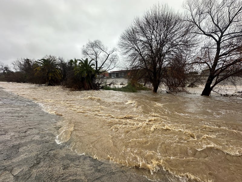
SAN FRANCISCO (CN) — A powerful Pineapple Express storm is pummeling Southern California, with much of the region under emergency alerts and flash flood warnings as flooding and power outages are already underway.
The low pressure atmospheric river storm became a “Pineapple Express” event over the weekend, so-called because its plume of moisture stretches from across the Pacific Ocean. More than 1 million people in the Los Angeles area are now at risk of flooding following up to 9 inches of rain falling by Monday morning, with some hillsides turning to mud and making evacuation difficult. Some areas are under evacuation orders regardless, such as the mountain and canyon areas of Monterey, Santa Barbara, Ventura and Los Angeles counties.
More than 430,000 customers were without electricity statewide by midday Monday, with the most power outages reported in Mendocino and Yuba counties in Northern California.
The National Weather Service said flash flooding and the threat of rapid, rocky mudslides presents “a particularly dangerous situation.”
“EXTREMELY DANGEROUS SITUATION UNFOLDING IN THE HOLLYWOOD HILLS AREA AND AROUND THE SANTA MONICA MOUNTAINS,” the service said in a post on X, formerly Twitter, on Monday. “Life threatening landslides and additional flash flooding expected overnight tonight. Avoid travel if at all possible.”
Downtown Los Angeles received a record 4.1 inches of rain Sunday, breaking the previous 1927 record of 2.55 inches. Sunday was the third-wettest February day ever recorded for the downtown.
Rainfall records were also set at Los Angeles International Airport and Santa Barbara Airport, at 1.76 and 2.39 inches respectively.
The Los Angeles Unified School District, the nation’s second largest school district, said all but two schools were open Monday. Schools throughout Santa Barbara County, which was devastated by mudslides caused by 2018 storms, were closed Monday.
The rain is expected to spread south to San Diego by Monday afternoon, with the most precipitation expected through Tuesday morning. The county’s coast and valley are expected to see half an inch of rain while the mountains could receive at least one inch, a far cry from the more than 150 billion gallons of water that fell on San Diego County over three days in January that led to flash floods.
Governor Gavin Newsom said in a statement Sunday that a record 8,500 emergency support resources are already on the ground to respond to the storm’s effects.
He issued a state of emergency proclamation for Los Angeles, Orange, Riverside, San Bernardino, San Diego, San Luis Obispo, Santa Barbara and Ventura counties, authorizing a California National Guard response if needed with unemployment benefits for impacted residents.
“California: This is a serious storm with dangerous and potentially life-threatening impacts,” Newsom said. “Please pay attention to any emergency orders or alerts from local officials.”
Further north, the weather service issued a rare “hurricane force wind warning” for the Central Coast on Sunday, with wind gusts of up to 92 mph from the Monterey Peninsula to northern San Luis Obispo County.
The storm brought down trees and electrical lines throughout Northern California, including in Sacramento and the San Francisco Bay Area. Winds topped 60 mph in some areas and above 80 mph in the mountains.
In San José, emergency crews pulled people from stranded cars and rescued homeless people and animals along the rising Guadalupe River.
Through Tuesday, parts of Southern California could still receive 1 to 3 inches of rain, particularly Orange County and the Inland Empire. The San Diego and Riverside County mountains could get up to 4 inches.
A smaller system is expected to arrive by Thursday, with at least an inch of rain possible especially in Southern California through Saturday.
“The additional heavy rain on top of the rain we already received will exacerbate the flood threat, especially for Orange County, northwest Inland Empire and especially the San Bernardino Mountains where catastrophic and life-threatening flooding is possible,” the National Weather Service’s San Diego meteorologists said. “The San Diego River is also forecast to reach a minor flood stage by early Tuesday morning, though more nuisance flooding of the usual streets around Fashion Valley may begin as early as tonight.”
Northern California’s coasts are not expected to experience significant rain again until Wednesday, with San Francisco meteorologists saying the “bomb cyclone” Sunday event is tapering off.
However, inland valleys such as the Sacramento Valley can continue to expect rain, and have already experienced significant damage due to extremely high winds. Heavy snow has been falling in the Sierra and will continue to impact travel in the higher passes until Wednesday.
 Follow @nhanson_reports
Subscribe to our free newsletters
Our weekly newsletter Closing Arguments offers the latest about ongoing trials, major litigation and rulings in courthouses around the U.S. and the world, while the monthly Under the Lights dishes the legal dirt from Hollywood, sports, Big Tech and the arts.