 Search Articles

SAN FRANCISCO (CN) — After a record-setting New Year’s Eve storm that brought widespread flooding to much of Northern California, the region is bracing for another storm that could bring historic levels of rain — and more flooding — to many vulnerable areas.
Starting Wednesday, a “Pineapple Express” storm heading east over the Pacific Ocean will make landfall. San Francisco Bay Area meteorologists have upgraded the storm to a Level 5 “severe” warning, as projections showed an unprecedented amount of rain could cause widespread flooding and dangerous conditions to low-lying coastal areas where flooding already affected many communities during the New Year’s Eve storm.
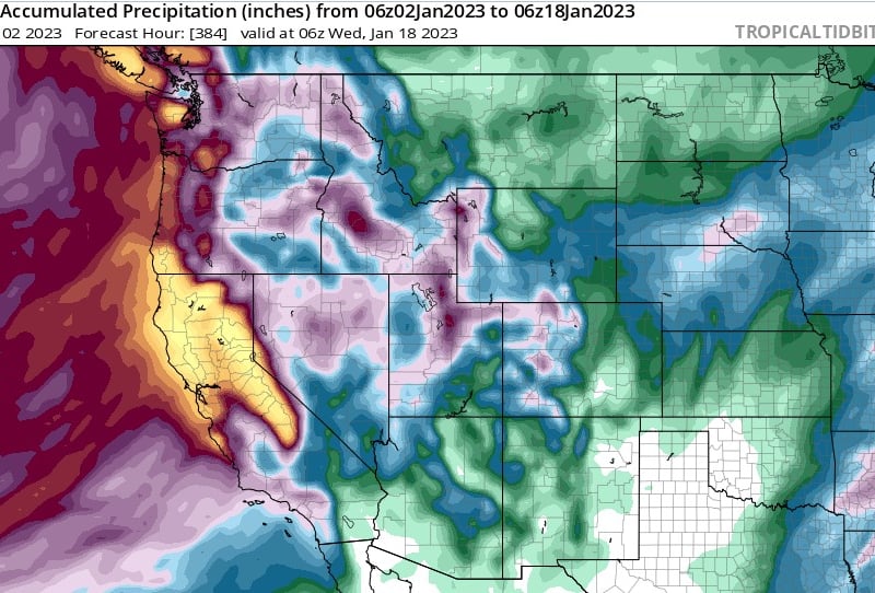
Record-setting rainfall has been forecast through Thursday, with the National Weather Service predicting up to four inches in the Sacramento Valley, three to five inches in the foothills and up to seven inches in the mountains by Wednesday evening.
‘’This could lead to areas of rapidly developing roadway & urban flooding, with possible impassable roadways due to flooding or flood damage, and rises on creeks, streams, and rivers,” the service reported.
According to a National Weather Service report issued Monday afternoon, the storm will “likely be one of the most impactful systems on a widespread scale that this meteorologist has seen in a long while.”
“The impacts will include widespread flooding, roads washing out, hillside collapsing, trees down (potentially full groves), widespread power outages, immediate disruption to commerce, and the worst of all, likely loss of human life. This is truly a brutal system that we are looking at and needs to be taken seriously. Beyond the midweek system the pattern will remain active and continue to have impacts on life, property, and commerce.”
A report released early Tuesday morning said a warm frontal band will start with light precipitation on the Central Coast by sunrise Wednesday, spreading across the entire north state by mid-morning. Strong winds ahead of the cold front could bring gusts of 40-60 mph, likely causing downed trees and limbs.
Forecast confidence remains high for widespread substantial rainfall over the coastal ranges, likely up to six inches and even eight inches in some areas, through Thursday. Meanwhile, most urban areas will get up to three inches, with up to about five inches in the North Bay.
“Of greatest concern will be flooding of rivers, creeks, streams, and other low-lying and flood-prone locations,” the report added. “This will also result in extensive street flooding in portions of the Bay Area and Central Coast, and an increased threat of widespread shallow landslides. Thus, a flood watch is in effect through much of the storm, which will begin to diminish Thursday night.”
The weather office also warned of flooding and landslide risks in recent burn scars such as in the area of the August Complex and Dixie fires, in the Sierra foothills and southern Cascades. However, the storm will also bring at least a foot of snow to many parts of the high Sierra range, according to the National Weather Service’s Reno office.
A New Year’s under water
Saturday’s storm dumped so much rain on the state that some parts of coastal and valley cities like San Francisco and Sacramento, flooded. San Francisco saw 5.8 inches of rain in a single day, prompting flooding emergencies in areas like the Marinaand Bernal as cars stalled in water and roads were blocked off. The situation around San Francisco International Airport became increasingly dangerous due to severe flooding on Highway 101.
Meteorologist Drew Tuma said on Twitter that it made for the second wettest day recorded in the city in more than 170 years.
“Since midnight we have seen 4.78" of rain. In the last 24 hours we have seen 5.19,” he said.
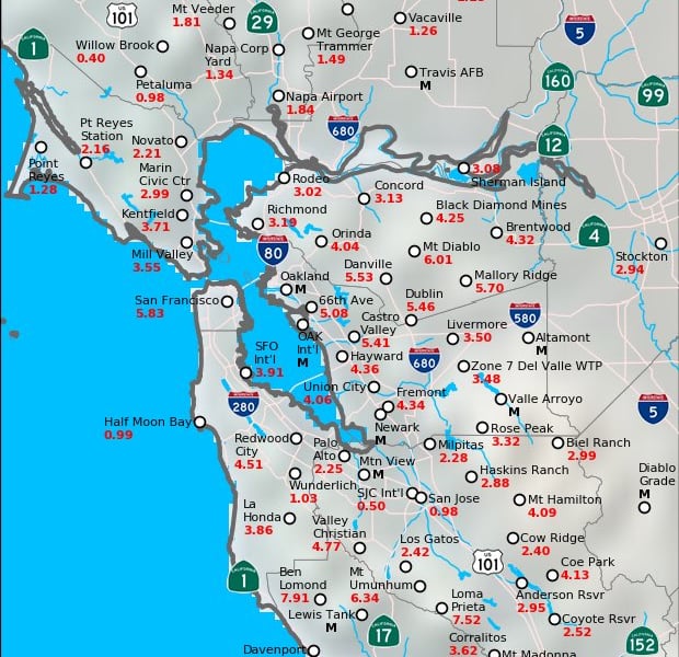
Parts of Oakland also flooded including the Lake Merritt area, causing multiple traffic accidents on Interstate 580. Berkeley bobbed under rising creek levels, as did Walnut Creek. Since Saturday, sinkholes have begun appearing from Daly City to the Oakland Zoo due to oversaturated soil and older infrastructure. And while the San Jose area saw less rainfall, there was still flooding in cities like Palo Alto.
Cities from Watsonville to Placerville also saw areal flooding, while Highway 99 south of Sacramento closed in both directions for more than a day after levees on the Cosumnes River tailed in two places and the river flooded the highway. Dozens had to be rescued from the vehicles and a person was found dead in their flooded car.
So much snow fell in the Sierra it created a standstill emergency out of Tahoe. Scientist Michael Steinberg reported from Donner Pass that blocked roads led to miles of bumper-to-bumper traffic. Caltrans reported multiple spinouts on Interstate 80.
But on the positive side, the weather service’s Reno station reported the New Year’s storm brought much-needed snow to address the ongoing drought. The Eastern Sierra saw between 35 to 54 inches of snow above 7,500 feet, followed by Tahoe Basin at 39-47 inches above 7,000 feet and up to 46 inches in the Truckee area.
More to come
Meteorologists say that beyond Wednesday’s storm, rainfall and wind will return for this weekend and possibly beyond.
“Ensembles are suggesting another significant precip event this weekend following potential for a prolonged/strong NorCal atmospheric river on Mon/Tue, but (with) substantial uncertainty,” Bay Area climate scientist Daniel Swain said on Twitter.
Another foot to two feet of snow could fall in the Sierra this weekend, while a bigger storm arriving Jan. 9 could bring moderate to heavy rain and snow. The stormy pattern continues with few breaks through the second week of January.
“While we are off to a good start so far in terms of snowpack, the drought is a result of multiple years of below average precipitation so while our current start helps, we would need to continue our trend of above average precipitation through the rest of this season and likely for additional seasons,” said Tony Fuentes, senior meteorologist in Reno.
 Follow @nhanson_reports
Subscribe to our free newsletters
Our weekly newsletter Closing Arguments offers the latest about ongoing trials, major litigation and rulings in courthouses around the U.S. and the world, while the monthly Under the Lights dishes the legal dirt from Hollywood, sports, Big Tech and the arts.