 Search Articles

(CN) — When the Earth started pulsing every 90 seconds in September 2023, scientists didn’t know what to make of it. The signal was global, rhythmic and bizarre and lasted for nine days, then came back a month later.
Now, nearly a year later, University of Oxford researchers say they’ve found the answer through direct observation — the first physical evidence of the waves believed to be behind the mystery, captured by cutting-edge satellite technology.
The discovery doesn’t just solve a geophysical puzzle. Researchers say it also highlights the kind of rare, extreme events that are becoming more likely in a warming world.
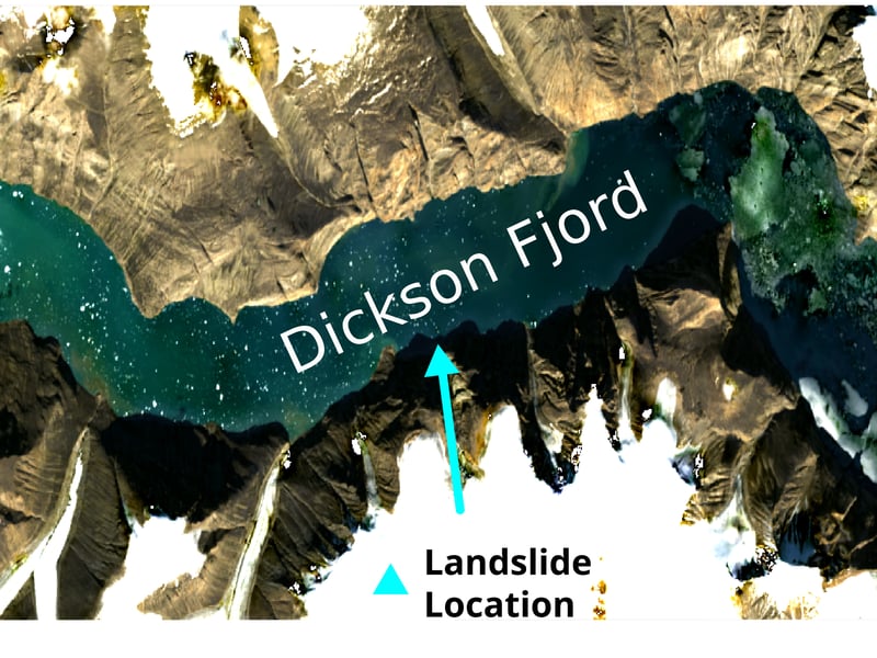
The findings build on earlier research, which suggested the signals were set off by a pair of massive landslides in a remote East Greenland fjord. According to researchers, those slides likely triggered mega tsunamis that became trapped in the narrow waterway, bouncing back and forth to form what scientists call standing waves, or seiches.
These weren’t just local disturbances, say researchers. They moved with enough rhythm and force to send ripples through the entire planet.
Until now, though, that idea hadn’t been confirmed. No one had actually seen the waves, not even a Danish military ship that arrived at the fjord just days after the first event. That left researchers with a strong theory but no direct proof.
In a study published Tuesday in the journal Nature Communications, a team at the University of Oxford found the proof they’d been looking for. They used data from the new SWOT satellite — short for Surface Water and Ocean Topography, which launched in late 2022 and can map water levels across most of the Earth with far more detail than older satellites.
Where previous tools could only scan directly beneath the satellite in narrow slices, SWOT collects wide swaths of data, offering a much fuller picture of what’s happening on the surface.
The researchers used that information to map the elevation of the fjord at several points after the landslides. What they saw matched the theory exactly: The water was tilting first one way, then the other, showing a clear back-and-forth motion across the channel. The height difference reached up to two meters.
To rule out other causes, they checked weather and tide data and also matched the wave movements with tiny shifts in the Earth’s crust, recorded thousands of kilometers away. That allowed them to recreate the full wave behavior, even during times the satellite didn’t pass overhead.
“Climate change is giving rise to new, unseen extremes,” said lead author Thomas Monahan, a doctoral student at Oxford’s Department of Engineering Science, in a press release. “These extremes are changing the fastest in remote areas, such as the Arctic, where our ability to measure them using physical sensors is limited. This study shows how we can leverage the next generation of satellite earth observation technologies to study these processes.”
According to the study’s co-author, professor Thomas Adcock, it’s just the beginning of what the technology can reveal.
“This study is an example of how the next generation of satellite data can resolve phenomena that has remained a mystery in the past,” Adcock said in the press release. “We will be able to get new insights into ocean extremes such as tsunamis, storm surges, and freak waves. However, to get the most out of this data we will need to innovate and use both machine learning and our knowledge of ocean physics to interpret our new results.”
Subscribe to our free newsletters
Our weekly newsletter Closing Arguments offers the latest about ongoing trials, major litigation and rulings in courthouses around the U.S. and the world, while the monthly Under the Lights dishes the legal dirt from Hollywood, sports, Big Tech and the arts.