 Search Articles

(CN) — New technological advancements have allowed scientists to create detailed maps of the beautiful and highly endangered coral reefs of Hawaii, paving the way for important developments in conserving them.
In a study published Monday in the journal Proceedings of the National Academy of Sciences, researchers made groundbreaking progress by developing a new method of mapping corals from an airborne observatory.
Coral reefs are richly biodiverse hotspots, home to more than 25% of marine species, and are some of the oldest ecosystems we have today. They thrive in warm, sunny waters, and are nourished by the algae that lives in their soft tissue. The algae provides important nutrients, giving them their vibrant colors and attracting tons of sea creatures.
Corals have withstood a lot in their time on Earth, but their defenses have been weakened by human activity and as a result are extremely fragile and easily disturbed by changes in their surroundings. They are very sensitive to changes in oxygen levels, pH and temperatures, and when any of these are thrown out of balance the coral can eject their algae and experience bleaching events.
Reefs in shallow water are at the most risk of disturbance by human activity like coastal development, agricultural runoff, pollution, fishing, and recreational misuse. Scientists predict that without swift preservation measures, 75% of coral reefs could be critically threatened by the year 2050. To prevent this, detailed and accurate maps are needed to determine where healthy reefs live, and which reefs are in the most danger.
Scientists have pursued this before, using satellites to try to gain a bird’s-eye view of the endangered coral reefs. This method did not provide enough detail to accurately gauge the threat levels of different regions, and mapping with field-based surveys was too limited a view as well.
The authors of the study found that airborne technology can gather the most complete observations in impressive detail of the reefs’ conditions. They hope this new method will allow them to identify live coral reefs and design specific conservation methods to protect them.
The team focused on Hawaii for their study, since it is rich in coral reefs facing the effects of human caused environmental stressors. Additionally, climate change has brought more intense heatwaves to the islands which cause tragic bleaching events. In 2015, the reefs suffered extreme loss from a heatwave, but the extent of the damage is still unknown.
Enter Arizona State University’s researchers from the Center for Global Discovery and Conservation Science. They designed and developed a new method of airborne mapping, capable of capturing well-rounded data of the reefs’ health. After applying this approach, they determined that live corals were distributed at “51 feet of water depth across the main Hawaiian islands.”
“We undertook this first-ever mapping of a large archipelago to determine where corals live in Hawaiian waters despite repeated heatwaves and problematic coastal development issues,” said lead author Greg Asner, director of the center. “It’s this basic information that is needed by partner organizations to drive more cost-effective protections, restoration activities, and public engagement.”
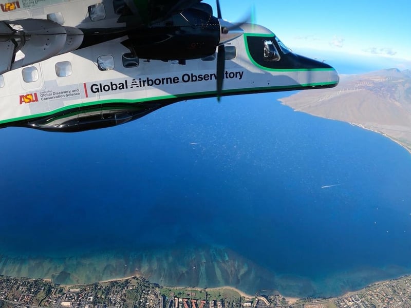
The aircraft responsible for this was the ASU Global Airborne Observatory, a flying laboratory with state of the art mapping technology capable of imaging the status of coral reefs in never before seen detail. It achieves this through the use of laser-guided imaging spectroscopy — a technique often used to map complex landscapes such as forests — and artificial intelligence.
“Operational mapping of live coral cover within and across Hawaii’s reef ecosystems affords opportunities for managers and policy-makers to better address reef protection, resilience, and restoration,” said co-author Brian Neilson, head of Hawaii’s Division of Aquatic Resources. “With these new maps, we have a better shot at protecting what we have while focusing on where to improve conditions for corals and the myriad of species that depend upon corals.”
After obtaining the data collected by the aircraft, the maps were combined with known data of marine and coastal activities and analyzed together in a computer algorithm. From that, they determined the location of the corals, and discovered that nearshore development poses a great threat to them.
The corals here face threats from fishing practices trying to sustain the growing occupancy of the islands, and fishing pollution can damage or even kill a coral. Tourism can also attract scuba divers who don’t know how to treat living corals and could step on them, unwittingly causing damage. And urban development causes toxic runoff to flow into the ocean from lawns, agriculture, golf courses and other sources that can kill reefs.
This development in coral imaging has the potential to raise awareness and highlight the biggest risks to these invaluable ecosystems, and put them on track to healing.
“Never before has there been such a detailed and synoptic view of live corals at this scale,” said co-author Jamison Gove of the National Oceanic and Atmospheric Administration. “These findings are foundational for developing place-based conservation and management strategies to promote reef persistence and mitigate further losses in corals across Hawaii.”
Furthermore, the technology even allowed them to identify the strongest, most resilient corals out of all the islands’ reefs and gave them the name ‘refugia.’ These sites show a resistance to human activity and environmental stressors that would normally disrupt other coral reefs, and the authors hope that they can be vital areas for coral conservation and restoration.
“We are trying to make major leaps on the science and technology side to directly address coral reef conservation and management challenges, starting in the Hawaiian Islands,” said Asner. “Our hope is that these outcomes will grow the discussion among communities, environmental managers, and elected officials, without which, we will continue to lose coral reefs right before our eyes.”
Subscribe to our free newsletters
Our weekly newsletter Closing Arguments offers the latest about ongoing trials, major litigation and rulings in courthouses around the U.S. and the world, while the monthly Under the Lights dishes the legal dirt from Hollywood, sports, Big Tech and the arts.