 Search Articles

SAN FRANCISCO (CN) — Already reeling from massive snowstorms in the last week, California is in for more rounds of heavy snow, rain and cold temperatures — leading forecasters to say this year “March starts with a roar.”
The recent winter storms slamming much of the state have brought snowfall, flood warnings and even rare blizzard warnings to parts of Southern California. The storms also led to many school closures across the state Monday due to messy highways and roads.
On Friday, Caltrans closed Interstate 5 north of LA County, a heavily trafficked roadway known as “the grapevine,” after snow blanketed the 40-mile stretch. The California Highway Patrol reported eight to 10 inches of snow falling on Tejon Pass. Other towns in California saw snow fall at sea level, including Santa Cruz and Eureka.
Another storm began moving in by late Monday. The National Weather Service wrote in a forecast discussion released Tuesday that the Reno, Nevada and Tahoe areas can expect another cold winter storm bringing several rounds of snow at all elevations through Tuesday night.
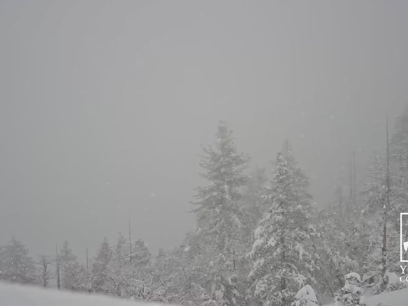
Fresh snow fell across the state at higher elevations Tuesday, including at the popular snow resort Mammoth Lakes which saw nearly two feet of fresh powder in the last 24 hours. The resort reported 646 inches of snow in total on the summit so far this season.
On Tuesday, UC Berkeley’s Central Sierra Snow Lab tweeted, “A very light and fluffy 36” (91.5 cm) of new #snow over the last 24 hours! That brings our 2-day total to 52.2" (132.5 cm) and our 7-day total to 109.3" (277.5 cm)! We are now within 6.5 feet of our 2016/2017 winter season (47.77 feet). Plenty more on the way!"
“An anomalously deep winter storm system making its way southeast into the Pacific Northwest continues to spin Pacificmoisture and rounds ofheavy snow into northeast California, the Lake Tahoe Basin and the eastern Sierra this morning,” Reno’s National Weather service forecast said Tuesday.
That means travel to the mountains is not recommended until the winter storm clears out. It also indicates a good chance of up to two inches of snow falling across most lower elevations, with some areas above 5,000 feet seeing several more inches. Snow showers at higher elevations will continue until Wednesday evening.
“Although March starts with a roar, a needed break in the stormy action will happen Thursday and Friday as a progressive upper ridge leans east into the western U.S.,” forecasters added.
“But that March lion is not done with us just yet. As the upper ridge axis shifts more east into the Rockies, increasing Sierra ridge top winds gusting 80-90 mph plus early Saturday will herald a southwest shift in the upper flow ahead of the next weekend winter storm.”
It is uncertain just how much precipitation, and when it will fall, will return this weekend.
Coastal areas including San Francisco can expect a break in rainfall Wednesday with a return to stormy weather Saturday. Regional forecasters said coastal areas will see very low temperatures during that break, with pockets dipping into the upper 20s in the North Bay, East Bay hills and the high country of Monterey and San Benito counties. Coastal areas including San Francisco County will remain in the upper 30s.
A freeze warning has been issued through Thursday for much of the Central Valley, with temperatures plunging into the upper 20s for an extended period both Tuesday and Wednesday nights.
As for Los Angeles County and much of Southern California, rainfall continues. A new forecast discussion said “it’s verylikely that accumulating snow will fall on the Grapevine tonight which could lead to additional road closures.”
“While seemingly unprecedented, it is not as we have had much colder and snowier pattern across the region in decades past,” the forecasters noted. “Otherwise, a warming and drying trend should shape up on Thursday with the downtown Los Angeles sensor finally breaking a streak of eight days below 60 degrees. This would be the longest streak since January 2005.”
Forecasters are fairly confident that the first half of March favors more wet weather. The Climate Prediction Center outlook predicts a 40-50% chance of above averagerainfall and a 60%-80% chance of below average temperatures in the San Francisco Bay Area.
However, “The only thing that is clear is that we`re in a wetter than normal pattern,” forecasters said.
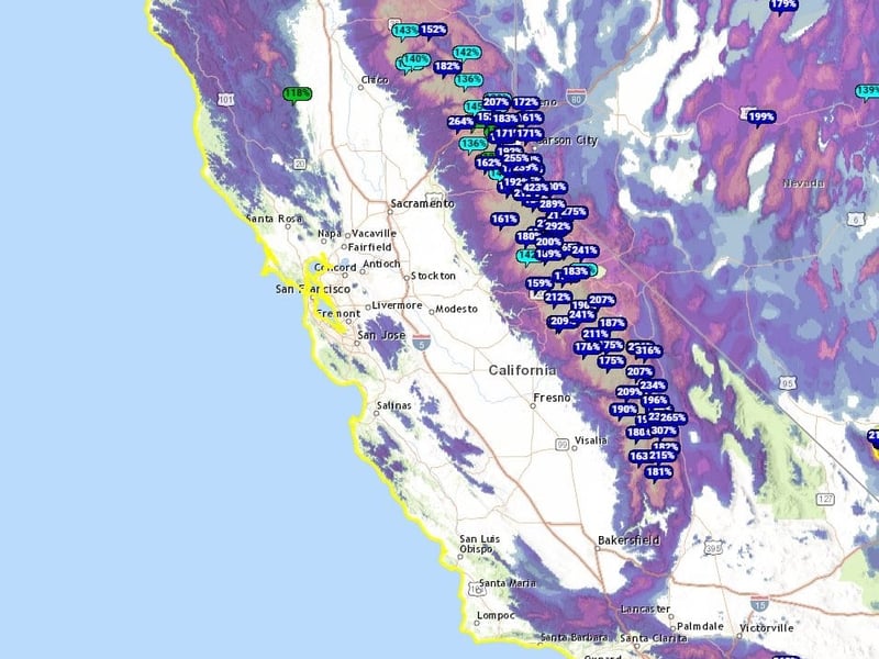
California’s Department of Water Resources, which reported an “incredible’” snowpack early in February, will conduct another statewide snowpack measurement and report Friday.
 Follow @nhanson_reports
Subscribe to our free newsletters
Our weekly newsletter Closing Arguments offers the latest about ongoing trials, major litigation and rulings in courthouses around the U.S. and the world, while the monthly Under the Lights dishes the legal dirt from Hollywood, sports, Big Tech and the arts.