UNION GAP, Wash. (CN) – Washington state resident Anthony Lundquist, 27, squinted up at a hunk of slowly sliding mountainside called Rattlesnake Ridge. Half a mile from where he stood selling his family’s oranges, geologists say a 20-acre chunk of basalt will soon crash down into the valley, potentially covering the busy highway and damming the river below. Lundquist bit into an orange like he was eating an apple. “I just hope I don’t get dusted from it,” he said.
A crack in the high desert ridge above the town of Union Gap was discovered in October. Since then, it has steadily widened into a gaping crevasse as a 4 million cubic yard chunk of bedrock is sliding down the mountain at a rate of 1.7 feet per week. Geologists say it will break off completely sometime between now and May.
Until then, it’s life as usual for the 6,110 residents of Union Gap – except for the 67 people who were evacuated from their homes directly below Rattlesnake Ridge. Jeff Emmons, the director of the Yakima Valley Office of Emergency Management, said the county had advised the evacuees that the move was likely permanent.
“We told them they should not plan to go back to their homes,” Emmons told Courthouse News.
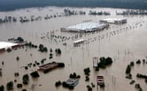
Effects could be severe for Union Gap, the 94,000 residents in neighboring Yakima and much of central Washington state if the worst-case scenario plays out. Interstate 82, with its 3,000 cars every day, could be covered by enough bedrock to fill 25 football stadiums. Basalt could dam the Yakima River and an irrigation canal that feeds the region’s vineyards and orchards, flooding the valley and its cities.
On the other hand, it’s possible that all that rock could simply settle in an open quarry just below Rattlesnake Ridge. Various owners have mined Anderson Quarry for decades in search of asphalt ingredients. But even if the quarry absorbed most of the landslide, oil and chemicals stored there could flow into Yakima River, where endangered salmon and threatened bull trout swim.
The Washington State Department of Transportation is using a laser monitoring system to track the landslide’s movement. Emergency managers created a barrier at the base of the ridge, placing dozens of concrete-filled shipping containers between the ridge and the freeway. Washington Gov. Jay Inslee said in a statement that he is ready to mobilize additional state and federal resources “the moment” they are needed.
Union Gap Mayor Roger Wentz said the town is getting plenty of help from dozens of government agencies.
“I think we have enough eyes on it that should the event start happening, we will be able to minimize any lives threatened,” Wentz said. “At least initially.”
Wentz worries about dangerous flooding but said the state should be able to divert water from upriver reservoirs long enough to get residents to safety.
State geologists say they won’t know what caused the slide until they observe its final descent. But the situation is unusual because it wasn’t caused by heavy rain saturating the soil. That’s what happened in Washington state’s 2014 Oso landslide, when torrential rain sent a hillside of mud and debris sliding down to swallow a highway and an entire neighborhood, killing 43 people.
Most of Rattlesnake Ridge is Columbia River basalt from a volcanic eruption that happened between 14 and 16 million years ago. It’s the same type bedrock that undergirds Portland, Oregon, a four-hour drive away.
Stephen Slaughter, landslide hazards mapping program coordinator with the Washington Department of Natural Resources, said the state is not yet investigating causes.
“We’re really focused on safety at this point,” Slaughter said. “Right now, we’re just collecting data to help emergency managers.”
But a landslide expert at Portland State University pointed to the quarry as a possible cause. Geology professor Scott Burns has been closely watching the landslide and the data that has been collected there.
“This one here was not caused by water or a big storm,” Burns said. “Probably the quarry has something to do with it, but we haven’t analyzed it completely. The quarry removed material that was supporting the rest of the slope, but we won’t know for sure until it fails.”
Anderson Quarry vigorously disputes that assertion.
“There’s no correlation whatsoever between our activities and the movement of that hill,” K.C. Klosterman, the company’s communications director, said by phone.
Nevertheless, the company footed the bill to evacuate the 67 people who live below the quarry, and has paid to hire consultants to help Washington State Department of Transportation monitor and analyze the slide.
Klosterman said the company is motivated by simple goodwill, not by any sense of responsibility for the impending landslide.
“We took it on our own accord to step in and help,” Klosterman said. “We realize that our industry is a heavy industry and we want to be a good neighbor.”
At its current rate of 2.5 inches per day, the slide is barely perceptible.
Mayor Wentz said the town is more excited to be the site of a major geological event than scared about potential danger.
“There’s a bit of concern there, but most people are very curious,” Wentz said. “It’s a combination of amazement and wonder at the natural phenomenon that’s happening with slight concern that hopefully nothing terrible will happen.”
On Tuesday, Yakima resident Gloria Sanches drove east along Interstate 82 below Rattlesnake Ridge to buy a bag of Lundquist’s oranges. Sanches said she didn’t see the point in changing her daily drive because of a catastrophic event that could happen on any one of the next 120 days.
“Looks like that big old slab is going to fall off,” Sanches said. “But heaven knows when.”
 Follow @@karinapdx
Subscribe to Closing Arguments
Sign up for new weekly newsletter Closing Arguments to get the latest about ongoing trials, major litigation and hot cases and rulings in courthouses around the U.S. and the world.