 Search Articles

(CN) — The National Weather Service is monitoring a severe storm system moving across the Southeast that has the potential to produce long-track tornadoes, damaging winds, hail the size of tennis balls, heavy rain and localized flooding.
Some school districts are closing early Tuesday as more than 1.2 million people are under an enhanced or moderate risk of severe weather, according to Ashley Jackson, a meteorologist in the NWS Jackson, Mississippi, office.
“We have a long wave trough moving through the southern plains into the Deep South, bringing a cold front,” Jackson said by phone Tuesday. “Ahead of the cold front, we have the ingredients to produce severe weather and more concerning, the system is fairly slow-moving.”
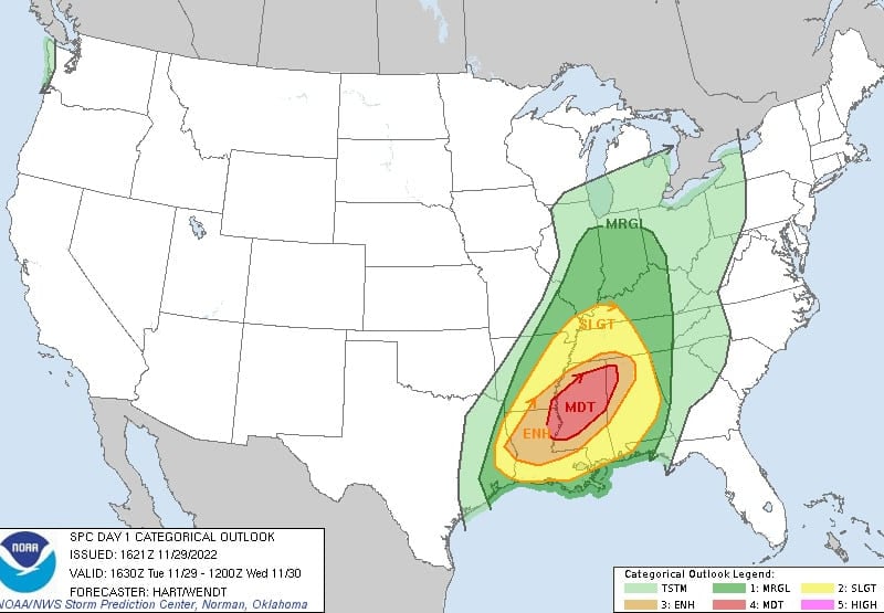
Moderate risk — a level 4 on the NWS scale, with 5 being the highest risk — is defined as a possibility of “significant and long-tracked tornadoes, damaging winds to 80 miles per hour and large hail.” The system is expected to grow more volatile as the day continues, with the threat level not falling until Wednesday morning.
“Typically when you see a higher risk, we have increased confidence of severe weather and we also have more favorable conditions for severe weather and that’s why we see that 4 out of 5 risk,” Jackson said, noting the Deep South experiences tornadoes more frequently in the winter months, particularly from November to March.
She added, “With hurricane season just ending we actually have two severe weather seasons on the Gulf Coast. This isn’t unusual, this is the time we typically see more tornadoes, but because this system is slow-moving it will be a longer period or duration than usual for severe weather potential.”
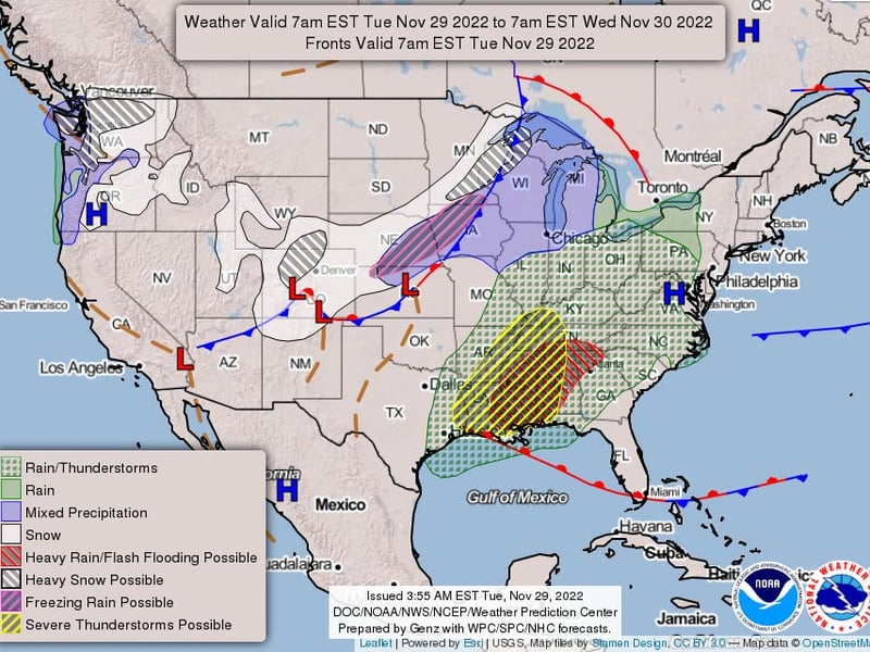
Counties in southeast Mississippi and southwest Alabama were already under a flood watch Tuesday morning. Severe thunderstorm warnings and other weather alerts will be issued as the front continues to develop and moves eastward, Jackson said.
The area of greatest concern is centered around U.S. Route 84 in Mississippi, but nearly the entire state is under some degree of risk, while portions of Louisiana, Alabama, Florida, Georgia and Tennessee are also in the crosshairs.
On Wednesday, the same system will create a marginal risk as it moves up the East Coast, but forecasters are not expecting it to produce additional severe weather.
In anticipation of the weather, the Mississippi Emergency Management Agency is urging residents and visitors to stay tuned to weather alerts, identify a safe place to bunker down quickly if necessary, prepare for power outages and stay off flooded roads.
The Louisiana Governor’s Office of Homeland Security and Emergency Preparedness tweeted that severe weather at night can create “additional problems” and encouraged citizens to charge their devices in anticipation of power outages.
The region has been under abnormally dry conditions, including a light drought in some places, but forecasts call for as much as 2 to 4 inches of rain.
 Follow @gabetynes
Subscribe to our free newsletters
Our weekly newsletter Closing Arguments offers the latest about ongoing trials, major litigation and rulings in courthouses around the U.S. and the world, while the monthly Under the Lights dishes the legal dirt from Hollywood, sports, Big Tech and the arts.