
 Search Articles


(CN) — The California Supreme Court on Thursday sided with the city of Oakland in a dispute with a property owner who claimed they were entitled to split up a piece of land for development because it was shown as multiple separate lots on an 1854 map of the area.
In an unanimous decision, the state’s high court agreed with the city that because the parcel had always been sold as one piece, it has never been carved into lots under the California Subdivision Map Act. As a result, the owner will have to seek the city’s approval if they want to carve it up into separate developments.
“The mere use of multiple lot numbers in the description of property being conveyed does not amount to a division of land that creates parcels for each of the individual lots,” Chief Justice Patricia Guerrero said in the court’s opinion reversing a 2023 state appellate court’s findings. “Thus, Lot 18 was never itself a parcel created as a result of a division of land during the time period specified by the statute.”
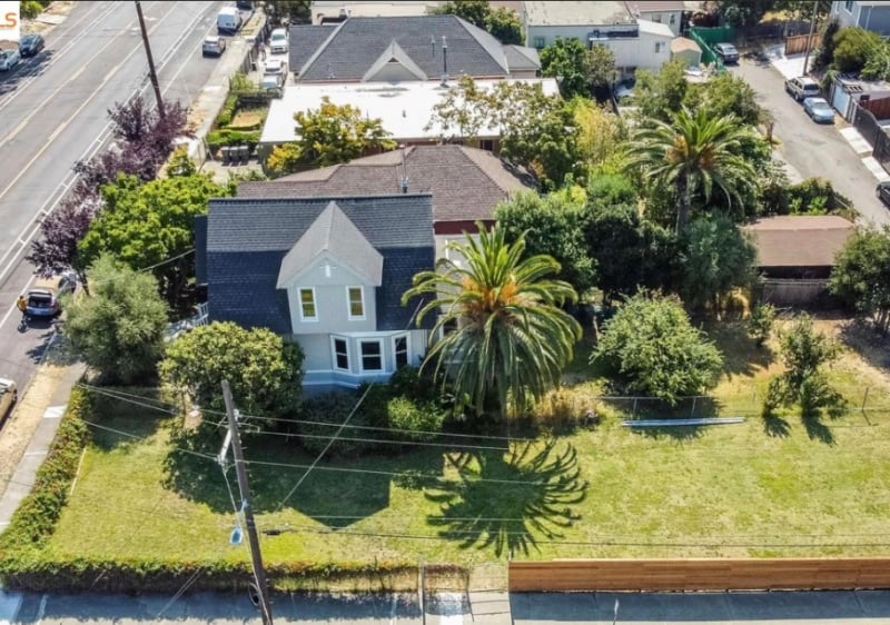
The property, on which sits one single-family home, encompasses two lots, 17 and 18, and a fraction of a third lot, 16, shown on an 1854 map of San Antonio, now part of the multicultural, low income area of East Oakland.
The owner, Crescent Trust, wants to split up the lots identified on the 1854 map for development, but the city maintains the lots have always been one parcel of land and can’t be subdivided based only on an antiquated map.
Crescent Trust had applied for a certificate of compliance asking the city to certify that Lot 18 was a separate parcel that had been legally created prior to March 4, 1972, when the California Legislature amended the Subdivision Map Act to require an approved parcel map for dividing land into fewer than five parcels.
When the city rejected the application, Crescent Trust petitioned a trial court to direct the city to issue the certificate. When that failed as well, the property owner went before a state appellate court, which overturned the trial judge’s finding and agreed that Lot 18 of the parcel was a lawfully separate piece of land under the state’s 1974 Subdivision Map Act.
The appellate panel ordered the city to issue a so-called certificate of compliance for the lot that would allow the owner to develop it separately from the part of the property on which the house sits.
At a hearing last November, an attorney for Oakland warned the court that the floodgates to “rogue” development would be opened if it didn’t overturn the appellate court’s decision that legitimized lots in so far as they only existed on 19th Century maps.
“Overnight you’re going to have tens of thousands, perhaps even hundreds of thousands, of legal parcels created,” Allison Ehlert said at the Nov. 5 hearing. “The effect of that really risks leading to a kind of rogue development within the state.”
The purpose of the Subdivision Map Act, she argued, is to foster orderly community development and to protect public health and safety. The thousands of newly created legal parcels for potential development would include substandard lots and lots in undeveloped areas that may require local governments to build out inefficient and expensive infrastructure to support housing there, according to the attorney.
Aaron Shechet, a lawyer for the property owner, urged the justices to look at the intent behind the transfers of the house and the land on which it sits from one owner to the next over the years, which specify the individual lots that are part of property.
“When we look at the evidence in the deed and the language used, what did the parties there intend” Shechet argued. “Did they intend to transfer multiple contiguous lots or they did just intend to transfer one lot?”
This line of argument, however, met with some skepticism from the justices, who observed that the language in the deeds may have referred to “lots” just as a convenient way to describe a property as a whole rather than to indicate a specific intent to transfer each enumerated lot as a separate piece of property.
“Plaintiff asserts that to evidence an intent to divide land under the common law, a deed could identify the land as separate parcels with reference to an antiquated map, even if those parcels were conveyed simultaneously on one deed,” Guerrero said in Thursday’s opinion.
“But plaintiff cites no authority to support this proposition, and we are not aware of any opinion holding that a deed’s mere identification of separate lots effectuated a division of contiguous land under common law,” she added.
Shechet didn’t immediately respond to a request for comment on the ruling.
 Follow @edpettersson
Subscribe to our free newsletters
Our weekly newsletter Closing Arguments offers the latest about ongoing trials, major litigation and rulings in courthouses around the U.S. and the world, while the monthly Under the Lights dishes the legal dirt from Hollywood, sports, Big Tech and the arts.