 Search Articles

SACRAMENTO, Calif. (CN) — Despite a recent bout of warm weather, California’s snowpack still stands at 241% of average for May, prompting experts to double down on warnings about spring flooding.
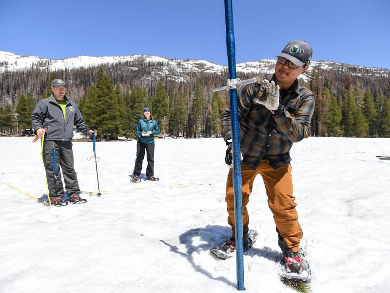
The California Department of Water Resources conducted a fifth snow survey of the season Monday at Phillips Station near Lake Tahoe. The survey recorded a snow water equivalent of 30 inches, which is 241% of average for this location. Readings from 130 snow sensors placed throughout the state indicate the snowpack’s snow water equivalent is 49.2 inches, or 254% of average, officials reported.
Recent winter storms brought the abundant snow and caused flooding in many counties including the central San Joaquin Valley. Experts warned a period of unusual heat in April could cause flooding risks in such vulnerable areas, but the snowpack has melted more slowly than average, or about 12 inches.
The state reported that average snowpacks have only measured above 200% in April during the winter seasons in 1952, 1969 and 1983.
“While providing a significant boost to California’s water supplies, this year’s massive snowpack is posing continued flood risks in the San Joaquin Valley,” said department director Karla Nemeth. “The snowpack will not disappear in one week or one month but will lead to sustained high flows across the San Joaquin and Tulare basins over the next several months and this data will help us inform water managers and ultimately help protect communities in these regions.”
Sean de Guzman, the state’s Snow Surveys and Water Supply Forecasting Unit manager, said technology is being used to forecast snowmelt and runoff.
“Survey results from our partners in the California Cooperative Snow Surveys Program and other data, including data from Airborne Snow Observatory flights, allow us to incorporate these data into our models to provide the most accurate snowmelt runoff forecasts possible right now to inform water supply, flood control and planning,” he said.
Due to the effects of climate change on California’s snowpack, since 2021 snowpack averages have been calculated using a timeframe of 1991 through 2020 to better reflect current climate conditions.
The banner winter spelled good news for drought-weary California: the U.S. Drought Monitor indicates most of the state is currently completely out of drought, with only areas in the southeastern desert regions and near the Oregon border measuring as abnormally dry or in moderate drought. The state has said the drought tracker does not account for snowmelt outcomes or how rainfall received over the winter will affect groundwater basins.
In April, the state announced that for the first time since 2006 it will allocate 100% of requested water from the State Water Project, which delivers to 29 public water agencies serving 27 million Californians and 750,000 acres of farmland. The state says it is also maximizing the water that can be diverted toward recharging groundwater basins for future use.
 Follow @nhanson_reports
Subscribe to our free newsletters
Our weekly newsletter Closing Arguments offers the latest about ongoing trials, major litigation and rulings in courthouses around the U.S. and the world, while the monthly Under the Lights dishes the legal dirt from Hollywood, sports, Big Tech and the arts.