 Search Articles

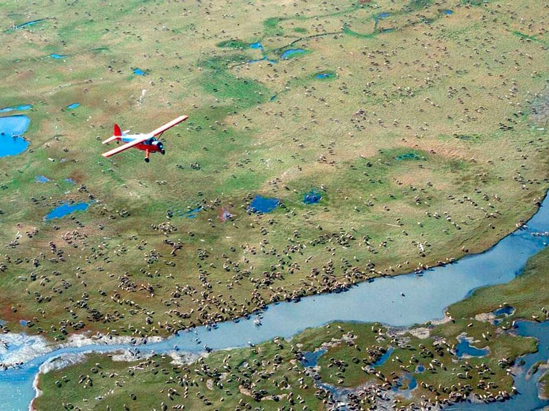
(CN) — A federal court in Alaska must decide what river marks the border of the Arctic National Wildlife Refuge, as the state accuses the U.S. government of improperly seizing more than 20,000 acres of land.
The land dispute has taken on new significance in recent months, as President Donald Trump has called for resource extraction in the Arctic National Wildlife Refuge. A federal court this week ordered the reinstatement of an Alaskan agency’s oil and gas leases there.
The crux of the dispute “boils down to the meaning of the phrase ‘extreme west bank of the Canning River,’” Kathleen Schroder, an attorney with the Denver-based Davis Graham & Stubbs firm representing the state, said at a hearing on Friday.
Located in the far northeast of the state, the Canning River flows north from the Franklin Mountains to Camden Bay in the Arctic Ocean.
In 1960, then-Secretary of the Interior Fred Seaton issued an order describing the boundary of the Arctic National Wildlife Range, which was later renamed a refuge. In the order, he described the boundary as moving in a southwesterly direction from Brownlow Point approximately three miles to the “mean high water mark of the extreme west bank of the Canning River.”
Alaska says Seaton intended for the Canning River to mark the boundary. The feds argue Seaton was instead referring to the Staines River, a more westerly channel of the Canning River.
Alaska cries foul. “Reading the public land order, the reference to the Canning River is not ambiguous,” Schroder argued. “The ‘extreme west bank’ just means the westernmost bank; it doesn’t mean a whole other river.”
U.S. District Judge Sharon Gleason questioned how the state could be sure geography wasn’t different when the order was issued.
“How do we know that wasn’t the case in 1960? That there was no Staines River in the Canning then?” the Barack Obama appointee asked.
Pictures of the area prove that the channel couldn’t have existed at that time, Schroder replied. Furthermore, she said, the order was issued without an accompanying map. That suggests the order was meant to stand on its own and be easily interpreted.
But the federal lawyers argue that when the public land order is read in the context of the time it was written, it is clear Seaton placed the boundary along the Staines River.
When looking at a 1906 geographic dictionary — a source which Justice Department attorney Michael Robertson argued the parties must reference — the Staines and Canning rivers are defined as one river.
“The Staines is the Canning,” Robertson said. The order was issued “smack in the middle at a point in time in 1960 when this is understood to be the same river.”
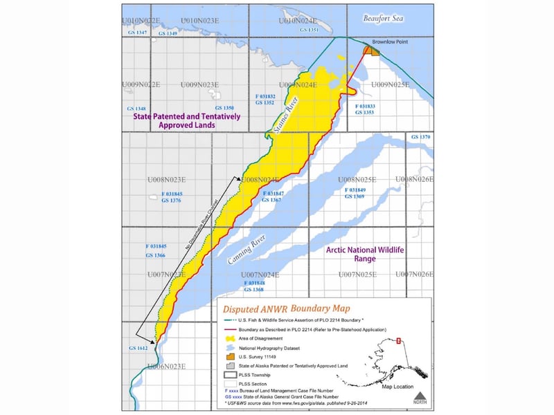
Alaska argues that geographic dictionary was outdated by 1960. The state says the court should instead instead reference a 1967 geographic dictionary, which defines the Staines as a tributary of the Canning. One problem: The latter dictionary came years after the order.
The dispute dates back to 2016, when Alaska challenged the Bureau of Land Management’s adoption of Arctic National Wildlife Refuge boundary along the Staines River. The state appealed to the Interior Board of Land Appeals, which agreed with the federal government. The state then sued.
The geographic mystery thickened as Alaska submitted several topographical maps of the area from the 1950s, which it hadn’t entered during proceedings before the Interior Board of Land Appeals. Gleason remanded the maps to the board for further consideration.
On remand, the board again kept the boundary along the Staines River. It said the supplemental maps didn’t alter its decision.
The federal government argues that if there had been any doubts the Staines River boundary was amiss, there were decades in which the border could have been contested or altered. Instead, in passing the Alaska National Interest Lands Conservation Act in 1980, it argues Congress confirmed the boundary of the refuge.
“Congress could have said ‘We’re going to move this, we don’t think you were right,’” Robertson said. “They didn’t do that.”
Still, Alaska argues the feds are conveniently overlooking a part of the Act it says equivocates on exact geography. It disagrees the matter is settled. After more than an hour of arguments and presentations, Gleason said she would study the maps more but didn’t indicate when she would issue a decision.
Subscribe to our free newsletters
Our weekly newsletter Closing Arguments offers the latest about ongoing trials, major litigation and rulings in courthouses around the U.S. and the world, while the monthly Under the Lights dishes the legal dirt from Hollywood, sports, Big Tech and the arts.